
Vancouver, British Columbia – 21 September, 2026 – Au Gold Corp (TSXV: AUGC) (the “Company” or “AUGC”) is pleased to provide details of two additional high-priority diamond drill targets at its Havelock Gold-Antimony project in Victoria, Australia.
- Shaw’s Main – untested, unmined continuation of the strongest gold mineralization interpreted from reconstructed historical mine records. Select grab samples from the mine waste dump returned 54.20, 25.10 and 16.70 grams per tonne (“g/t”) gold, respectively.
- Rob Roy – down-plunge continuation of ultra high-grade shoots and two parallel reefs associated with a doubly plunging structural architecture where mineralization is documented up to 36 inches wide, containing visible gold.
Marc Blythe, Founder & CEO of Au Gold, comments, “The Shaw’s Main and Rob Roy past producing mines are quality drill targets with the potential for shallow high-grade gold discoveries beneath the historical workings. While the Rob Roy mine reported specimens ‘amongst the richest seen in the Maryborough district’, Shaw’s Main had the highest historical production of all the mines within the Shaw – McFarlane Trend (SMT) and sampling by AUGC confirms the tenor of this mineralization. Au Gold is building an inventory of drill targets with additional work ongoing as we prepare for drilling to commence.”
Previous drill targets defined on the SMT were released September 16, 2026.
Shaw’s Main Target
Shaw’s Main mine is situated along the southern portion of the series of mines defining the 9 km long SMT. The workings exploit 360 metres (“m”) of northerly trending mineralization to a mined depth of 152 m. This is the deepest gold mineralization documented along the SMT. Figure 1 illustrates the plan view location and historical long section reconstruction of the mine with the primary focus on the lowest level of the workings.
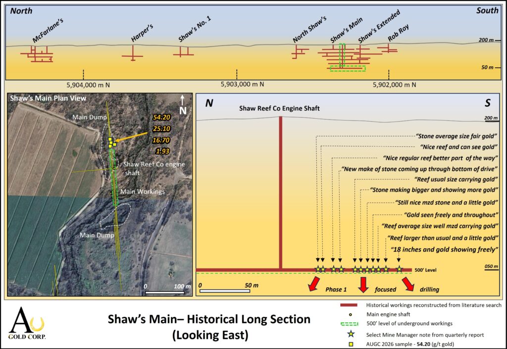
The gold-bearing reef at Shaw’s Main is interpreted as subvertical with a slight tendency to dip steeply eastward between some of the mine levels. At the lowest level (152 m) south of the main engine shaft, the mine manager’s records describe an 80 m section of continuous reef mineralization with descriptions including: “Nice reef and can see gold”, “Stone making bigger and showing more gold”, “Gold freely seen throughout” and “18 inches and gold showing freely”. No mine exploration was carried out below this level.
The mine closure was due to insufficient pumping ability of ground water inflow. Additionally, the reef was reported to be narrowing in the northern portion of the mine prior to the closure however, pinch and swell characteristics are commonly noted throughout the workings.
In June 2026, AUGC personnel accessed the main dump north of the Shaw’s Reef Co. Engine Shaft, roughly in the central part of the workings. Four composite samples of varying degrees of laminated quartz vein/reef material were collected from the top of and around the periphery of the mine dump. This material is believed to represent the deepest levels of the mine. Results for all four samples are contained in Table 1 with the strongest laminated quartz material returning 54.20 g/t gold from a 1.88 kg sample.
Table 1: Shaw’s Main Sample Results
| Sample Number | Sample Weight (kg) | Gold (g/t) |
| A111362 | 1.88 | 54.20 |
| A111363 | 1.21 | 25.10 |
| A111366 | 1.28 | 1.93 |
| A111367 | 2.13 | 16.70 |
AUGC’s diamond drill program will initially target the 80 m section directly beneath the 500-foot level where the mine manager’s records have documented gold-bearing reef mineralization.
Rob Roy Target
The Rob Roy mine is the southernmost of the significant historical mines on the SMT. It has documented some of the richest material in the Maryborough district, yet it was only mined to a depth of 200 feet (61 m) and along trend collectively from three levels for approximately 145 m.
The Rob Roy reef mineralization is situated approximately 150 m west of the main Shaw’s line of workings. It is not known if this reef is structurally offset or if it represents a parallel mineralized system to the SMT.
The general long section position, plan view and detail long section attributes are shown in Figure 2.
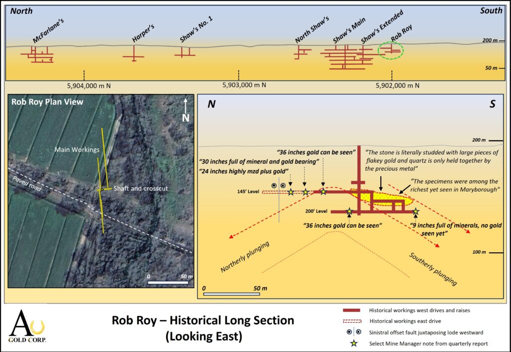
The western development of the mine produced the majority of the 293 ounces of gold reported at an average grade of 52 g/t. One section of the mine south of the main shaft between the 145 feet (44 m) and 165 feet (50 m) drive levels, encountered an ultra high-grade shoot and mineralization was described as ‘Stone literally studded with large pieces of flakey gold and quartz is only held together by the precious metal’. The steep westerly dipping reef was calculated to have a southerly plunge of approximately 30 degrees in this part of the mine.
Continued development at the 200-foot (61 m) level encountered reef mineralization with visible gold up to 3 feet in width. Heavy ground water flow impeded operations coupled with narrowing of the reef mineralization in this part of the mine and development was limited to 80 m strike length.
Following the closure of the western development, a late eastern cross-cut from the main shaft at the 145-foot level discovered a parallel reef roughly 10 m to the east with similar thicknesses and gold-bearing description as the reef documented in the western drive at the same level. It is uncertain why the western drive was not developed further north as one of the last mine manager’s reports described the reef to be 36 inches wide and “gold can be seen”. The parallel reef in the eastern cut is noted to be “30 inches full of mineral and gold bearing – 24 inches highly mineralized plus gold”. In addition, the mine manager also concluded this portion of the reef system to be northerly plunging which indicates potential for structural thickening proximal to the hinge.
AUGC plans to initiate drill testing in the vicinity of the hinge line directly beneath the 145- and 200-foot levels where gold-bearing mineralization was last documented in the mine manager’s records. Additional drilling will also be conducted at the southern end of the development to trace the continuation of the ultra high-grade mineralized zone down plunge.
Next Steps
AUGC continues to prepare for diamond drilling on the Shaw – McFarlane Trend and other peripheral targets.
The drill targets identified in this release are planned to be drilled from sites located on Crown Land. The proximity of the drill sites to Four Mile Creek requires additional preparatory work which has commenced.
The Company continues to engage with the community, in particular private landowners within areas of interest on the project.
Historic Information
AUGC cautions that the historic mine reconstruction work has relied on records which pre-date the introduction of NI 43-101. The reconstruction involved collating public records, comprising public company disclosures and newspaper articles, primarily from the late 1800’s and sorting them chronologically. Some of these records are online while others are only available at certain repositories on microfilm. AUGC reminds the reader that no mineral resources exist on the project and there is no certainty that exploration will result in the definition of mineral resources, despite the reported historic production.
A visual representation of each individual mine of significance has been rendered from these records. The reader is cautioned that the information may contain inaccuracies and may be incomplete in areas. Laboratory analyses were not carried out during this era and comments on the quality of material mined are therefore subjective and based on visual inspection. The language used reflects the era in which the work took place. Tonnages of material mined and treated are detailed in the historic records, along with the number of ounces of gold produced, which were generally disclosed on a quarterly basis.
The widths of gold-bearing quartz veins encountered in these historic mines has often been recorded and ranges from 3” to 3’6” (0.075 – 1.07 m). AUGC has relied upon these historic disclosures and reconstructions to interpret its high-priority phase 1 drill targets. It should be noted that even with potential deficiencies in the historical documentation, the level of detail is considered invaluable.
Qualified Person
Technical information in this press release was prepared under the supervision of Mr. William Wengzynowski, P.Eng., a Qualified Person as defined by NI 43-101. Mr. Wengzynowski is AUGC’s Exploration Manager.
Sample Analysis
Analytical samples were transported by Company personnel to On Site Laboratory Services (“On Site”) located in Bendigo, Victoria, Australia. On Site operates under both ISO 9001 and NATA quality systems. Samples were prepared and analyzed for gold using the fire assay technique (PE01S method; 25 gram charge), followed by measuring the gold in solution with flame AAS equipment. On Site inserts blanks and standards into the analytical process, AUGC did not insert additional QA/QC samples.
For further information, please contact:
Au Gold Corp
Marc G. Blythe, MBA, P.Eng., President & Chief Executive Officer
David Jan, Investor Relations
1-888-807-4566
About Au Gold
Au Gold Corp (TSXV: AUGC) is a gold exploration company focused on advancing its flagship Havelock gold-antimony project in the Victorian Gold Fields in Australia and the Ponderosa gold project in the Spences Bridge Gold Belt in British Columbia, Canada. More information at www.AuGoldCorp.com
Cautionary Note
This release includes certain statements and information that may constitute forward-looking information within the meaning of applicable Canadian securities laws. Forward-looking statements relate to future events or future performance and reflect the expectations or beliefs of management of the Company regarding future events. Generally, forward-looking statements and information can be identified by the use of forward-looking terminology such as “intends” or “anticipates”, or variations of such words and phrases or statements that certain actions, events or results “may”, “could”, “should”, “would” or “occur”. This information and these statements, referred to herein as “forward-looking statements”, are not historical facts, are made as of the date of this news release and include without limitation, statements regarding discussions of future plans, estimates and forecasts and statements as to management’s expectations and intentions with respect to, among other things, future exploration activities including drilling on the Project.
These forward-looking statements involve numerous risks and uncertainties and actual results might differ materially from results suggested in any forward-looking statements. Such risks and uncertainties include, among other things, the ability of the Company to obtain sufficient financing to fund its business activities and plans, delays in obtaining governmental and regulatory approvals (including of the TSX Venture Exchange), changes in laws, regulations and policies affecting mining operations, currency fluctuations, market uncertainty, as well as those factors discussed in the Company’s most recently filed management’s discussion and analysis and other filings of the Company with Canadian securities authorities, copies of which can be found under the Company’s profile on the SEDAR+ website at www.sedarplus.ca.
In making the forward looking statements in this news release, the Company has applied several material assumptions, including without limitation, that the Company will be able to obtain sufficient financing to carry out its planned exploration activities.
Although management of the Company has attempted to identify important factors that could cause actual results to differ materially from those contained in forward-looking statements or forward-looking information, there may be other factors that cause results not to be as anticipated, estimated or intended. There can be no assurance that such statements will prove to be accurate, as actual results and future events could differ materially from those anticipated in such statements. Accordingly, readers should not place undue reliance on forward-looking statements and forward-looking information. Readers are cautioned that reliance on such information may not be appropriate for other purposes. The Company does not undertake to update any forward-looking statement, forward-looking information or financial outlook that are incorporated by reference herein, except in accordance with applicable securities laws. We seek safe harbour.